 |
Edinburgh International Surface Link
Outline proposals for review and comment |
||||||||||
| Home | EARL, Gogar and trams | Development and objectives | EISL A | EISL B | Conclusions | About |
|
The grade-separation serves two purposes. Firstly, it enables the junctions that form an inherent part of the EISL proposals to be adjacent to the station and to avoid any flat crossings. Secondly, by lowering the eastbound tracks, it ensures trains climbing from the future Fife line loop to the new station (past the west end of the airport runway under the EISL A3 proposals) will have a gradient no greater than 1:115.
The station will be 1700m south of the airport terminal and connected to it by a dedicated shuttle.
The EISL A1 route will require the acquisition of land from Easter Norton Farm, Norton Mains, the Gogarburn Golf Club and the new site of the RHC at Norton Park. In addition, some land within the grounds of the Norton House hotel will be acquired for the realignment of the tracks to the west of the new station.
|
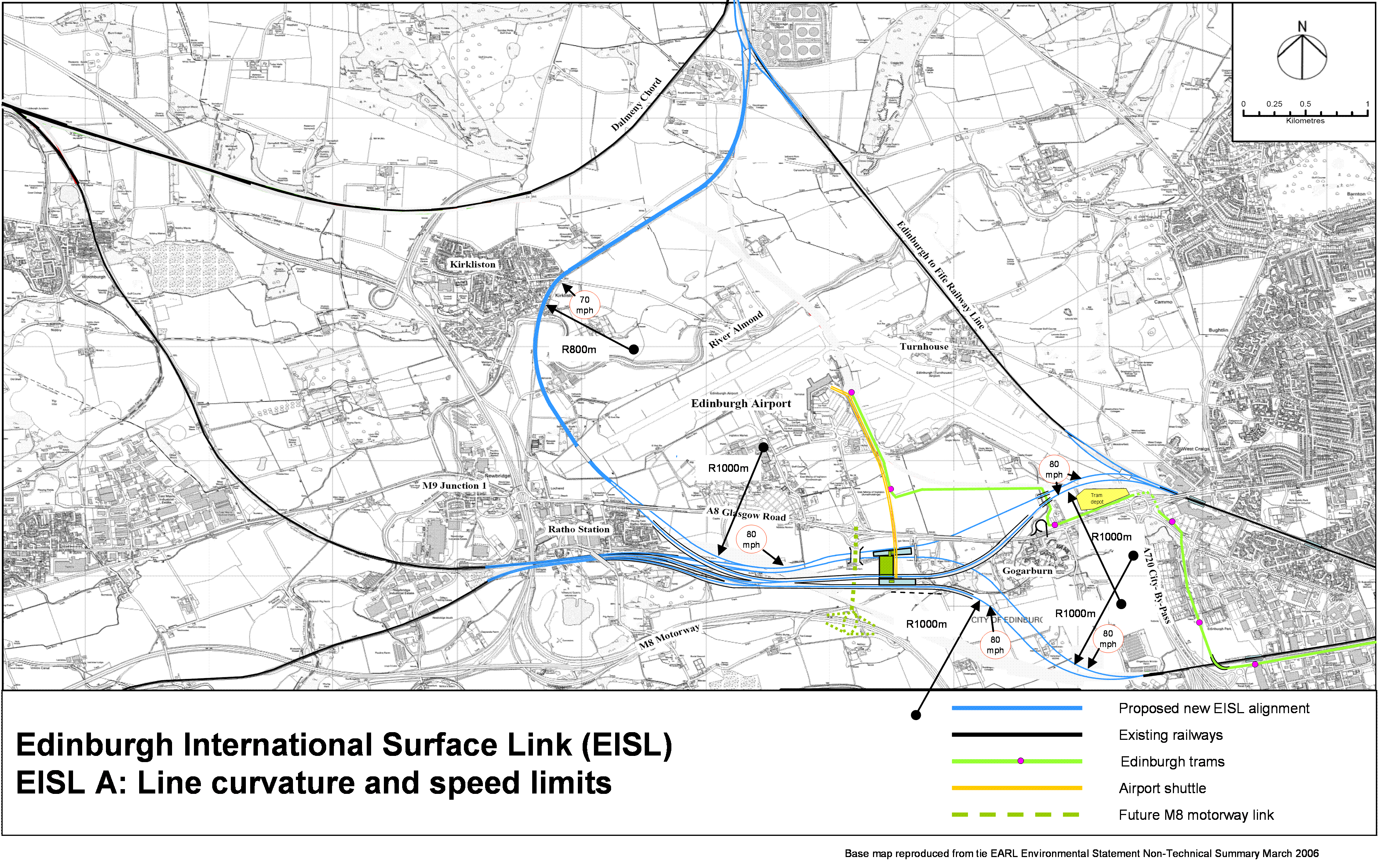
EISL A curvature and speed limits 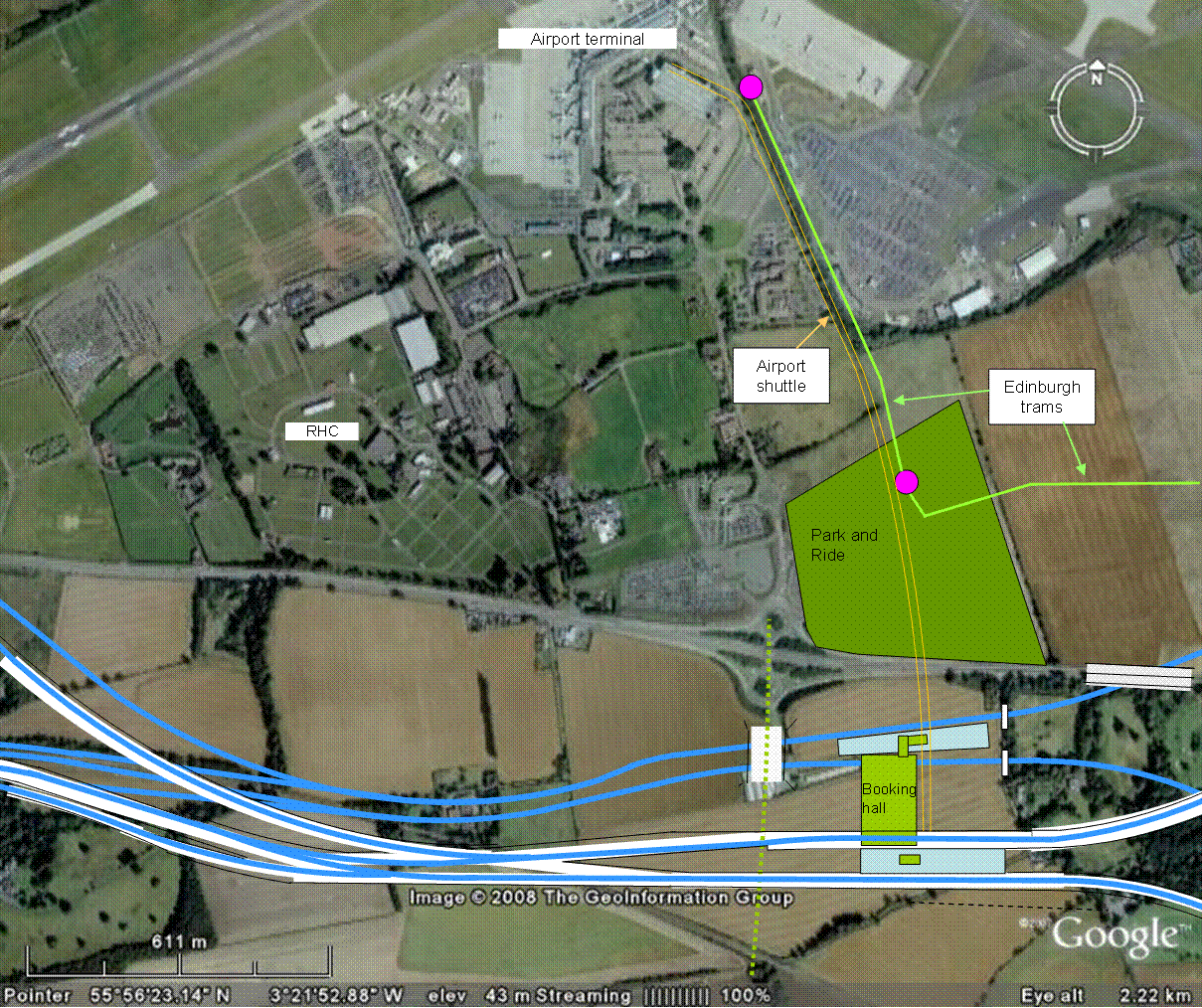
EISL A station site |
||||||||||||||||||||||||||||||||
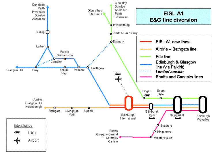
EISL A1EISL A1 routeEISL A1 diverts the E&G line through the new Edinburgh International station, enabling service by trains to and from Dunblane, Glasgow (via Falkirk) and Glasgow (via Airdrie). The journey to the airport will be approximately forty minutes from Glasgow (via Falkirk), one hour from Glasgow (via Airdrie) and fifteen minutes from Edinburgh Waverley. The introduction of the extra station stop between Edinburgh and Glasgow will add no more than four minutes to the overall journey time of each train, allowing a station dwell time of 150 seconds.The diversion will use only one face of each of the two island platforms and so will not enable any change to the running pattern of services. However, the rail layout will provide grade separation for the divergence of the Airdrie-Bathgate line from the E&G line and thereby improve operational flexibility. It replaces the current flat junction at Newbridge. With EISL A1, no train from Bathgate will be delayed awaiting a train towards Falkirk to cross its path. Figure 6 shows the route diagram of stations served. Figure 7 is a diagrammatic representation of the track layout (not to scale). Appendix A1 shows a scale map of the proposed rail alignments. Figure 8 shows an aerial view of the route. Appendix A5 shows the track curvature and line speeds. Appendix A6 shows the rail gradients and elevations. Newbridge to Ratho
The tracks along the 500m between the grade-separated junction at Ratho and the current site of Newbridge junction will be converted from two tracks to four tracks. This will require the reconstruction of the Harvest Road bridge. In addition, the elevations of the tracks will be reconfigured, such that the two tracks towards Edinburgh fall at a gradient of 1:100 from Newbridge to the new Ratho junction. Thereafter the gradient will ease gradually to a fall of about 1:500 through a cutting into the station’s lower platform. The current cutting between Ratho and Newbridge, although shallow, is in rock and the widening and deepening of this cutting will be expensive, especially as the work must be done mostly with the E&G lines remaining live. We have estimated Ł50 million for this civil engineering. We have also allowed Ł13 million for a bridge over the eastbound tracks west of the station for a future M8 motorway link.
|
EISL A1 service 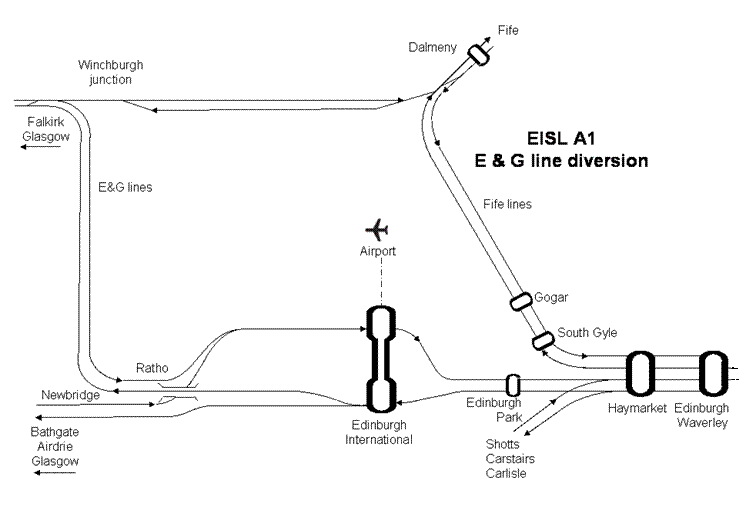
EISL A1 track configuration (diagrammatic - not to scale) 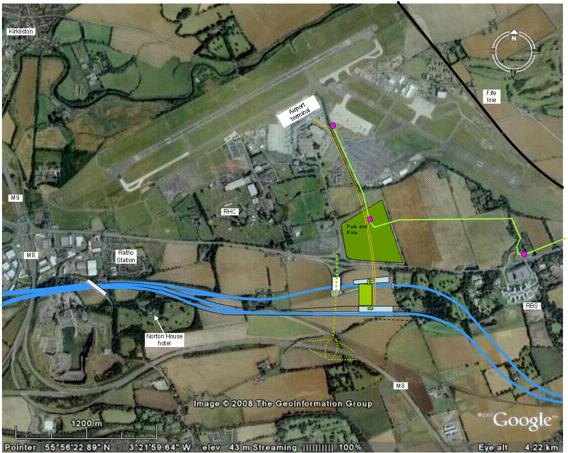
EISL A1 aerial view |
||||||||||||||||||||||||||||||||
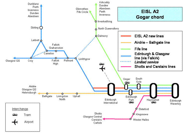
EISL A2EISL A2 routeEISL A2 provides a chord from Gogar to Edinburgh International, replacing the function of the Government’s proposed Dalmeny chord. It will allow trains travelling to Glasgow (via Falkirk) to use the northern pair of tracks from Waverley through Haymarket. This will balance the traffic density on the four tracks through Haymarket and allow more trains to stop at Edinburgh Park, because of the reduced density of traffic on the line through that station.Figure 9 shows the stations served by EISL A2. Figure 10 is the track diagram (not to scale). EISL A2 will bring into use the northern flanks of each of the two island platforms at Edinburgh International, such that the station will then have four operational platforms. This will greatly improve operational flexibility. Trains to and from Falkirk can use either the northern tracks through Gogar to Haymarket, or the southern pair of tracks through Edinburgh Park. With the projected high density of traffic on both the E&G line and the Airdrie-Bathgate line, this flexibility will be important to allow signallers to recover from train delays or other disruption. Figure 11 shows an aerial view of the EISL A2 alignment. Appendix A2 shows the alignments in detail and to scale. Gogar junctionA new grade-separated junction will be built at Gogar on the Fife line, immediately north of the A8 road. This will be eased greatly if the Government’s proposed station at Gogar is built south of the A8. The northbound track will be realigned slightly westwards and lowered to pass under a new rail bridge. The westbound EISL A2 track will diverge just south of this new bridge and skirt the depot for the Edinburgh trams. This track will climb steadily at about 1:150 to reach an elevation of +53m to cross over the tram line and the Gogar burn just north of the road bridge serving the RBS campus. The westbound line will then join a viaduct that will carry it over the A8 road and the Gogarburn golf course to run into the north flank of the westbound platform at elevation +58m.The eastbound track from the northern flank of the lower platform (elevation +43m) will also rise at about 1:150 passing through a new bridge under the A8 road to reach +50m at the Gogar burn, sufficient to clear the tram line as well as the burn. From here, the line will fall gently to the new Gogar junction. EISL A2 alignmentTo the west of Edinburgh International station, the new westbound line will leave the northern flank of the platform on a new viaduct, joining the E&G line east of Ratho.The new eastbound line will diverge to the north of the E&G line immediately east of the Harvest Road bridge at Ratho Station. It will fall with a maximum gradient of 1:80 into a very deep cutting until it reaches an elevation of +40m. This is the point at which the future EISL A3 line from the Fife loop will join. It is possible that detailed analysis will show that a short section of tunnel would be more cost-effective over this 800m stretch than a deep cutting which will require a high retaining wall for the adjacent EISL A1 eastbound line which will be up to 5m higher. From the point of the future junction, the EISL A2 line rises steadily at about 1:300 to reach the northern flank of the eastbound platform (elevation +43m), passing under the passive box bridge providing for a future M8 link over the rail line. |
EISL A2 service 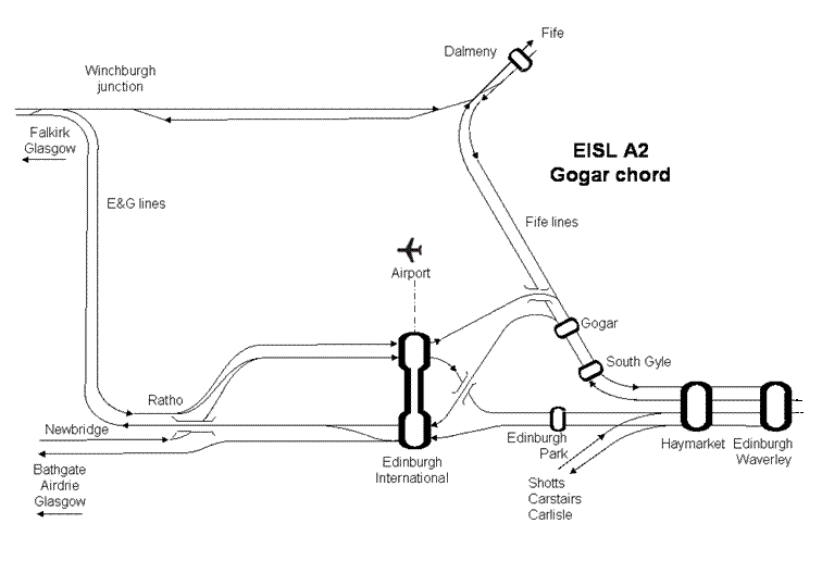
EISL A2 track configuration (diagrammatic - not to scale) 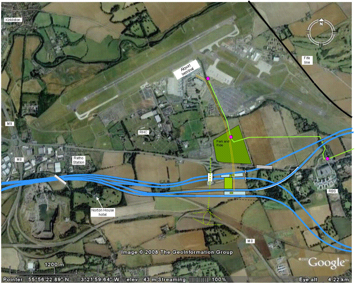
EISL A2 aerial view |
||||||||||||||||||||||||||||||||
EISL A3EISL A3 routeEISL A3 completes the EISL A project by providing a loop for trains to and from Fife to pass through the new station. It is this phase of the project that has constrained the elevations of the rail lines for the whole EISL A design.The EISL A3 proposal is for a loop on the Fife line, not a diversion. It complements the existing line to the east of the runway. The flagship timings for services from Edinburgh to Aberdeen and Inverness will only be retained by maintaining the current line and skipping the airport stop. The EISL A3 loop will add about seven minutes to journey times (including a dwell time of 150 seconds at Edinburgh International station). Figure 12 shows the route diagram of stations served. Figure 13 is a diagrammatic representation of the track layout (not to scale). Appendix A3 shows a scale map of the proposed rail alignments. Figure 14 shows an aerial view of the route. Appendix A5 shows the track curvature and line speeds. Appendix A6 shows the rail gradients and elevations. EISL A3 alignmentThe northbound EISL A3 line will diverge from the track serving the northern flank of the westbound platform at Edinburgh International. It will run over a new high viaduct bridging the eastbound EISL A lines and then fall very rapidly at a gradient increasing to 1:60. It will maintain this steep downward gradient until it passes through a new bridge under the A8 road at Ratho Station. Thereafter, the gradient eases until the line passes into airport property to the west of the main airport runway.Runway endThe existing Fife line passes to the east of the main airport runway at an elevation of about +35m, sufficient to bridge the River Almond. This is a few metres higher than the airport runway and is an irritant to the airport authorities because it prevents any lengthening of the runway to the east. The EISL A3 proposal does not provide for the line to the east of the runway to be decommissioned.The EISL A3 alignment crosses the centreline of the runway approximately 300m beyond its south western end. The line will traverse the airport grounds in a cutting such that no rail infrastructure (including future overhead line electrification) will be above current ground level. In line with the runway, the railway will be enclosed in a box, to allow airport lights and other instrumentation to be mounted above it, and to provide a safe overrun area for the runway. It also retains the option of westward lengthening of the runway. Figure 15 is an aerial view of the alignment.
Construction of this box will use the cut and cover method. This will require close co-operation with the airport authorities and some restrictions on aircraft activities for short periods to allow heavy lifting with cranes. The cost estimates reflect this requirement, assuming that lifting work is limited to night periods when the main runway can be closed or restricted. Ł38 million has been estimated for the cost of this box alone (Ł55 million with optimism bias). This is extremely high for a simple twin-track concrete box structure but the estimate has been inflated to reflect the highest possible complexity of project management, restricted site access, and working in unsocial hours. It also allows for the airport operator to be compensated for the cost of temporary relocation of airport lighting and communications and their subsequent reinstatement on the new railway box. It is likely that the box could be constructed for much less if the airport operator co-operates fully.
Reinstatement of disused Kirkliston railwayFrom Newbridge to Dalmeny, the EISL A3 alignment exploits the disused railway track bed through Kirkliston. This track bed is currently used as a footpath and cycleway. We have been unable to confirm whether this line was ever double track but we do know that there was a passing loop at Kirkliston. The line closed to passengers in 1930 and to all trains in 1966. The trackbed appears adequate to carry a double track railway and we judge that relatively little earthwork would be necessary to provide a double trackbed. In Kirkliston there are some new residential buildings in the vicinity of the old station that encroach on the trackbed. These new houses would be very close to the proposed EISL A3 railway and it will probably be necessary to acquire some of these houses. In any case, residents are likely to object to the construction and operating disturbance. Costings for the reinstatement of the line therefore include an allowance for offering purchase at market value of some of these properties.Other residents and local politicians are likely to press for the station to be reinstated at Kirkliston. However, the EISL A3 proposals presented here make no provision for a station and do not consider the effects on journey times for Fife trains of a stop at Kirkliston. The trackbed includes a bridge over the River Almond just south of Kirkliston. This appears to be in reasonable condition but the costings include a sum of Ł3.5 million for possible restoration works on this bridge. Figure 16 shows an aerial view of the bridge. Dalmeny junctionAt its northern end, the EISL A3 loop will rejoin the Fife lines south of Dalmeny at a new grade-separated junction. |

EISL A3 service 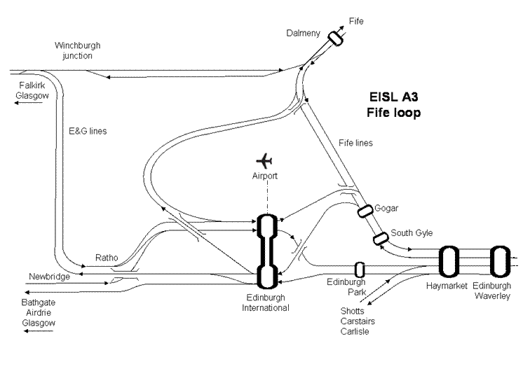
EISL A3 track configuration (diagrammatic - not to scale) 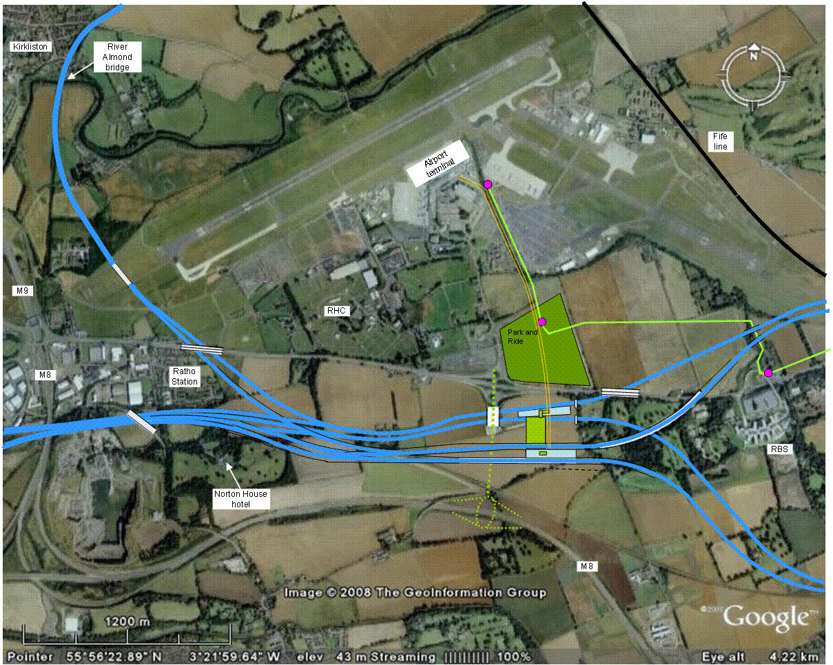
EISL A3 aerial view |
||||||||||||||||||||||||||||||||
EISL A Airport shuttleThe design of the EISL A airport shuttle will need to be subject to a separate feasibility study. The technologies available, and their costs, vary greatly. At one extreme is the simple cable hauled system with two opposing shuttles. Birmingham Airport uses this system but its track length is only 585m and the shuttle travels no faster than 36km/h. Its capacity is limited to 1600 passengers per hour. The cost of replacing Birmingham’s original Maglev with this cable hauled system was only Ł11 million. This system cannot be expanded to have more than two shuttles and it appears unlikely that this technology would be adequate for the distance and passenger numbers required for EISL A.A more sophisticated arrangement is the shuttle between terminals at Gatwick airport in London. This extends for 1,210m connecting the South Terminal and railway station with the North Terminal. It is an elevated, two-way automated people mover track. The transit shuttle normally consists of two automatic, three-car, driver-less trains. The shuttle opened in 1987, along with the North Terminal. The shuttle was renewed in 2009, with a new operating system and shuttle cars at a total cost of Ł45 million. We have adopted assumptions for Edinburgh International of 24 shuttles per hour each way over the 1,700m between the station and the airport with the shuttle trains initially each capable of carrying 60 passengers with luggage trolleys. Future expansion, by lengthening the shuttle trains, would enable each shuttle to carry 90 passengers, giving a capacity of 2,160 passengers per hour. For this arrangement, the central cost estimate is Ł135 million for a self-propelled automatically controlled shuttle service running on conventional elevated tracks, recognising that this is the most uncertain of all EISL costs. |
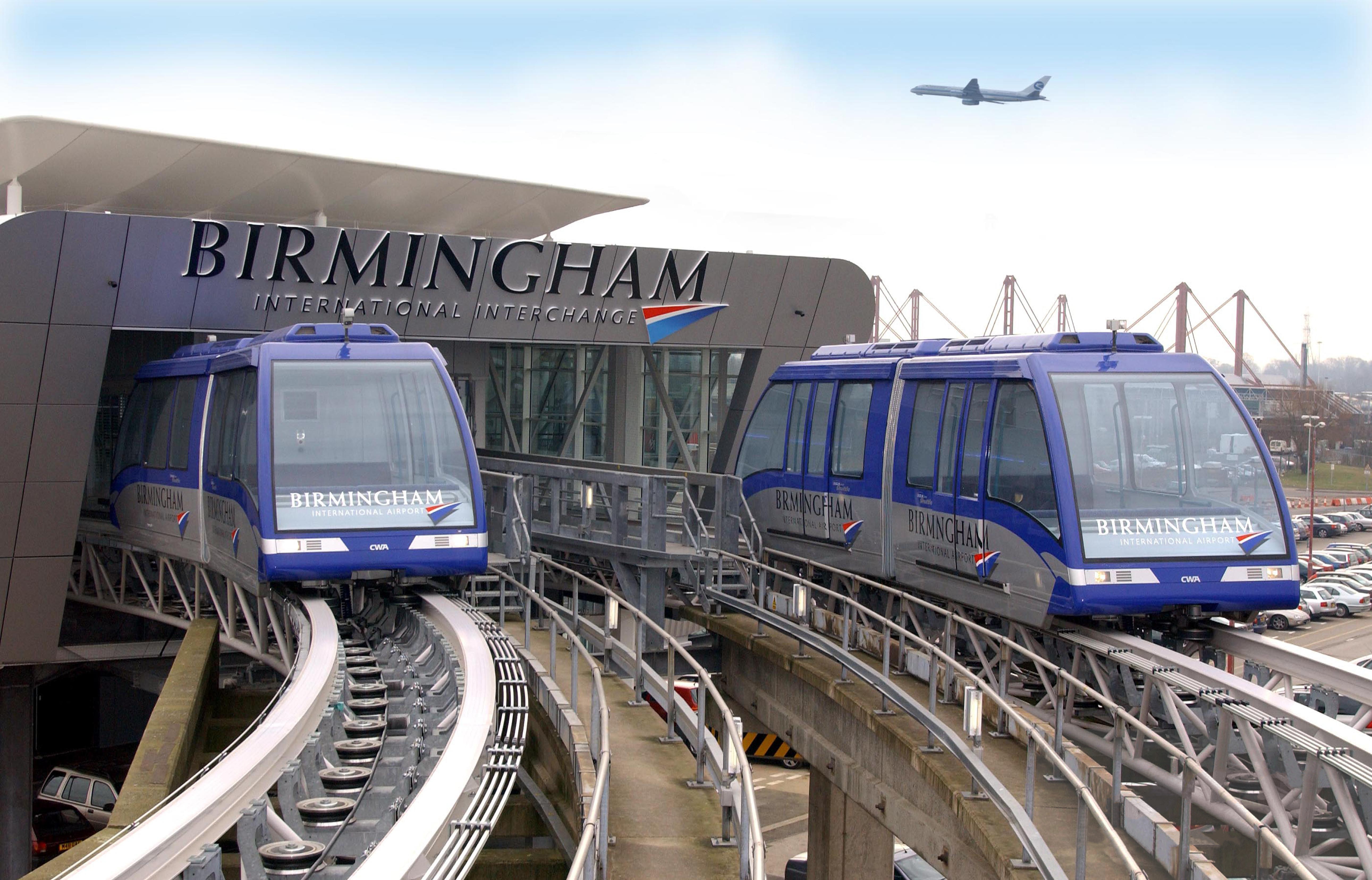
Birmingham International shuttle 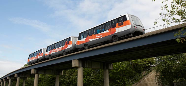
Gatwick shuttle |
||||||||||||||||||||||||||||||||
Airport expansion and RHC relocationThe EISL proposals have been developed to be flexible to future development. Specifically, the proposals are compatible with plans for airport expansion and for the move of the RHC to a new site south of the A8 road. However, the EISL proposals are dependent on neither of these developments.In analysing future airport expansion, we have used the plans included in the 2003 DfT assessment which considered options for expansion of Edinburgh Airport beyond 2030. The more recent (2006) BAA MasterPlan for Edinburgh Airport is less specific about plans for the terminal building but the indicated footprint of the airport is similar to that used by the DfT assessment. Plans are advancing to relocate the RHC to Norton Park, south of the A8 road. However, this move is not yet financed and it cannot be assumed that the move will occur. We have taken the sketch from the RHC’s 2006 Annual Report as the best indication of the proposed plans for the new site. Appendix A4 shows an overlay of the EISL A proposals on the drawings of the airport expansion and the relocation of the RHC to Norton Park. |
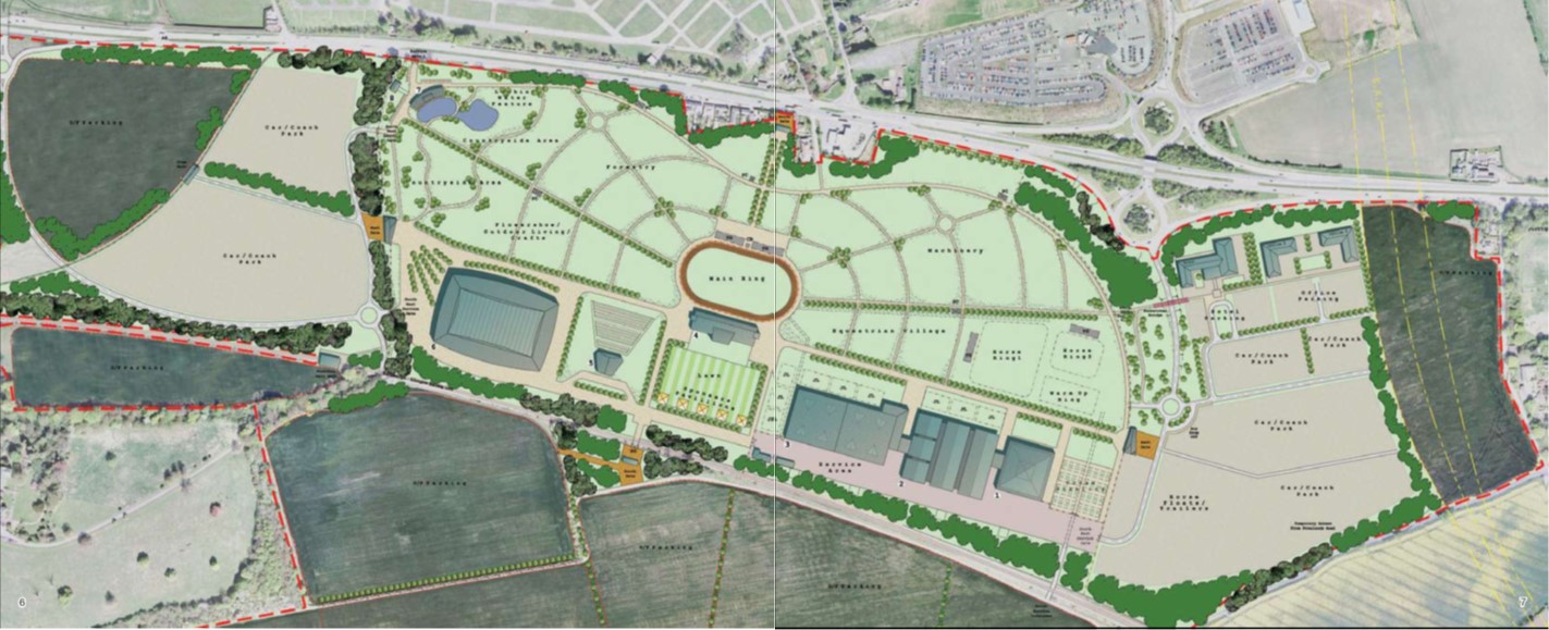
RHC relocation to Norton Park (2006 proposal) 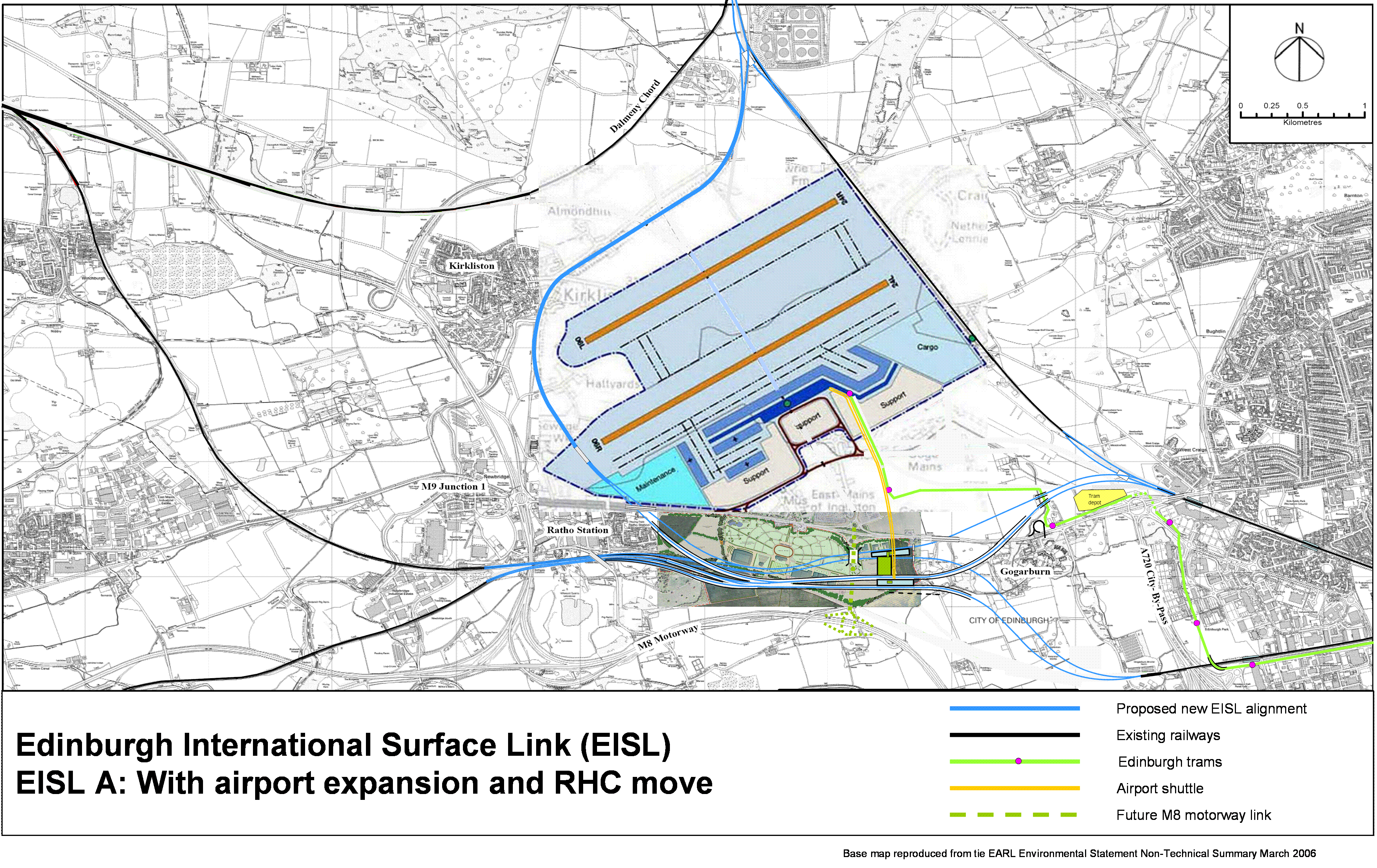
EISL A airport expansion and RHC relocation |
||||||||||||||||||||||||||||||||
EISL A costsCapital costsTable 2 shows the benchmark costs for each phase of the EISL A proposals, assuming that they are constructed over a number of years as three separate projects. A summary is on the right, showing the total estimate for EISL A of Ł890 million.
However, if there were the political and economic imperative to construct all three phases simultaneously, there could be savings of about Ł46 million. These costs have been prepared based solely on desk studies benchmarked against comparable projects. No site surveys have been conducted. The costs are generally likely to fall well within the optimism bias allowed for, but the costs of the airport shuttle remain very uncertain until the technology to be employed is determined. The total benchmark costs for all three phases of the EISL A proposals, including 44% optimism bias, are Ł890 million. This is more than the EARL proposal but offers a major boost to the transport infrastructure of the central belt of Scotland with a transport hub that is future-proofed against a decline in aviation and would protect the economy of west Edinburgh and the central belt. Operating costsIndicative marginal annual operating costs for EISL A are Ł6 million. This includes: Ł1.5 million for the operation and maintenance of the station buildings and facilities; Ł1.5 million for the maintenance of 15km of extra track (compared with the Gogar station and Dalmeny chord alone); no net increase in signalling costs; Ł3 million for the operation and maintenance of the airport shuttle.Lower cost optionsThe EISL B proposals offer a lower cost alternative, both in capital and operating costs. |
|
Comments on the proposals are welcome and should be sent to: admin@eisl.org.uk